
Search Maps
Latest Maps
Image
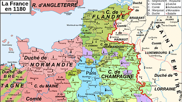
Map of 12th-Century France
A map showing the various counties and duchies of France at the end...

Image
Poland-Lithuania at its Greatest Extent, 1619
A map showing the Polish-Lithuanian Republic at its greatest territorial...

Image
Map of the Four Khanates of the Mongol Empire, c. 1300
This map illustrates the four major khanates that emerged from the Mongol...

Image
Map of the US-Mexican War of 1846-1848
This map illustrates the US-Mexican War of 1846-1848, triggered by the...


